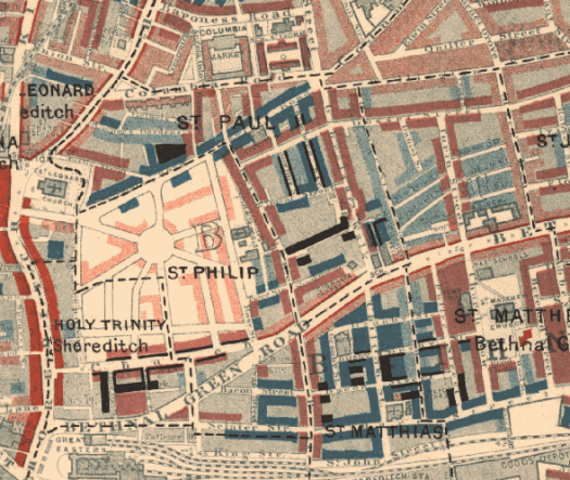
Steam Highwayman III Reward Pledges

In just over a week, Steam Highwayman III: The Reeking Metropolis will go live on Kickstarter. It’s taken a long time to plan this campaign, partly because I’ve chosen to add some merchandise into the equation, as well as offering two ways in which Backers can see themselves in the finished book.

The basic pledge is exactly like in my previous campaigns; for £15, backers can receive a copy of the gamebook with a written acknowledgement printed in the back. This is a little cheaper than the RRP and, of course, you’ll know that you helped create this. If you’re looking for extras, I’ve been working on custom dice, as well as beginning to redraw the maps from Smog and Ambuscade and Highways and Holloways. These will be printed, large (at around A2 size) and folded, together with a small booklet of further regional info, much like an OS map. For £30 you will be able to receive the book, three maps (one for each volume) and two custom D6.

If you don’t yet own your own copies of Smog and Ambuscade and Highways and Holloways, or if you’d like to make a pledge as a gift for someone, you can also have all three books at a considerable saving, with or without the maps and dice.

However, for an additional cost of £10 for one book or £20 for three, you can have a custom Wanted Poster printed into the front of your book. This is made possible by the power of print-on-demand, and your books will be completely unique – these will be true one-offs. The extra pledge will pay for the additional printing cost and contribute towards the rest of the project. You will be able to submit a digital image of yourself (perhaps a photo in costume, or even in everyday clothes) that I will edit into the poster, and this will be the first thing you see when you open your copy of The Reeking Metropolis.

Finally, there is a limited and exclusive opportunity to be drawn into the book itself, featuring as a character in one of the illustrations. This is going to be limited to only 5 backers, since it impacts directly on Russ’s timeline and on the whole budget. But it’s something I’ve wanted to offer for years! As part of your pledge, you’ll receive each book, customised with a Wanted Poster, the three maps, dice and an art print of your illustration for your wall. After all, YOU are the Steam Highwayman!

If you’re not currently following the Kickstarter, head over there now. You’ll be reminded on launch and get a chance to pledge for your reward straight away.

A Child of the Jago

Now that my gin is bottled, I’ve been putting in some time sketching passages 301-400 of Steam Highwayman III: The Reeking Metropolis. Like with the two previous volumes, I began by laying down a web of interlinked location passages. This portion represents the east central portion of the map: Bethnal Green, Shadwell, Whitechapel and Shoreditch.

There is so much to write here in an alternate, steamed-up East End. Body-snatching, sweat shops, front-room industry, the London Docks… and the slums.

Shoreditch has a big hole in it in 1894…

My usual map of recourse has an interesting gap just here: take a look. And hereby hangs a tale.

In 1896, a now-forgotten novelist called Arthur Morrison published an angry and brutally honest story called A Child of the Jago, set in a fictional slum based very closely on streets immediately adjacent to Old Nichol Street in Shoreditch. It follows the fortunes of Dicky Perrott, who scrapes through childhood and into a criminal survivalism that seemed unbelievable to polite readers of the day. This was at the end of the Victorian period, when the bad old days were meant to have been left behind. But they hadn’t been.

The text is available online and it makes tough reading. I don’t find it over sentimental or graphic – just frank. Morrison was trying to rub his reader’s noses in the reality of desperate poverty just streets away from their own lives, much in the way that we see independent documentary makers nowadays. But one result is that it really prevents me from being too sentimental or simplistic about the depiction of the poor in my own gamebook. There’s no way I can do justice to those realities in the little passages I use, but at least I hope to avoid cartoon poverty.

The Old Nichol – marked by black and dark blue housing

If you go looking online, you may find that there is a Covent Garden tailor that uses the name of Morrison’s book, which I find really quite distasteful, as I don’t think a romanticisation of the criminal dandies implicit in the clothing on sale is at all helpful. Or you may find one of the little maps that show the location of the Old Nichol. It was located on one edition of Booth’s Poverty Map, but by the publication of the more widely available edition, the Old Nichol had been cleared and replaced with social housing… that the original inhabitants could not afford, displacing them to other slums and destroying what community they had. Plus ca change, eh?

After the slum clearance

One more little detail: do you notice the thick red lines on the left? Shoreditch High Street. Up the top, St Leonard’s Church, whose bells say ‘When I grow rich…’ in the East End rhyme Oranges and Lemons. That’s a interesting place in itself, as the burial place of Shakespeare’s business partner and fellow actor, Richard Burbage. But you might recognise it as St Saviour’s from Rev, in which Tom Hollander did his best to minister to a desperately poor inner-city parish.

Rev.

Shoreditch is entirely different nowadays, though, isn’t it? Hipsters and hamburgers and cold-press coffee and cycle shops. Well, to be honest, I think there’s still a lot of hidden needs and poverty in Shoreditch. It’s enough to make me wonder what the unseen, spiritual dimension is behind all of these stories. There’s something desperate there.

Maps

I’ve written before about how Steam Highwayman I and II are both based on Ordnance Survey Maps in the Explorer series – specifically OSE 171 and OSE 172 But in fact these are more than just inspiration. The nature of Steam Highwayman as an open-world gamebook, like Fabled Lands before it, depends on having a network of locations and routes between them on which to string the various encounters. Once I had decided which towns, villages and locations I wanted to feature, I then drew these out onto a simplified map and began allocating pages. These first two books are really built around these maps.

While I was writing Highways and Holloways I went looking for older maps to complement my plotting. Did you know that the Library of Scotland has a searchable database of old maps available online? Well, it does and it’s amazing. It’s amazing.  Here it is: https://maps.nls.uk

For example, here’s a shot of Marlow in 1897 – a bit late for Steam Highwayman, but fascinatingly Victorian and basic.  Compare it with the modern satellite image beneath.  The difference isn’t massive – in fact, if you visit Marlow, you can feel a bit like you’ve travelled in time.  There’s more development to the west, but very few buildings have been replaced.

Old Marlow – 1897

New Marlow – 2018

But now look at London.  Steam Highwayman III will be set in central London, and nowhere has changed in the past hundred years more than the city of London.  The alleys and garrets and markets and old churches and tunnels and tenements…  Oh wow.  Much more exciting than the ridiculous post-modern glass and sliced-granite banks that occupy an entire block.

Old City of London – 1893

New City of London – 2018

Now Steam Highwayman isn’t set in a real past – but it’s purposefully set in a realistic past.  My conceit is that I can take a England that was real in around 1785 – when Prince George married Maria Fitzherbert, if you want to know – and imagine a similar but parallel historical development from that point.  This is called the ‘departure point’ in the study of allohistory, or alternate history, which is really a sub-genre of science fiction or speculative fiction.

So having maps that strip back England to a pre-electric age, before urban sprawl and before the petrol engine, doesn’t have to restrict me but can inspire me.  When I made the first Steam Highwayman map I began by taking the map of Marlow and the surroundings and removing all the A roads and motorways, imagining that the highways and holloways and tollroads became more important, rather than being superseded by carriageways that crush and swerve and…  Well, perhaps you get the idea that I am quite an old-fasioned sort when it comes to roads.  In this respect, Steam Highwayman is my fantasy about an older, slower, kinder England with no bypasses.

And the old maps of the National Library of Scotland do the whole job for me- with a pleasing sepia tone.  Go on – see if your house was built in 1897.  The London maps come down to an amazing scale, at which the owners of businesses and even houses are named.  Incredible.